Private Range Safety
Done Right
BUILT FOR SAFETY.
DRIVEN BY PRECISION.
Used and trusted by private range owners, clubs, and law enforcement training facilities across the U.S.
OUR MISSION
We help prevent that. Range Operations brings clear, professional SDZ mapping and safety assessments designed to protect your club, your members, and your reputation. When the standards are rising and expectations are tightening, having a trusted expert ensures you stay safe, compliant, and open.
Every range carries risk, but most never see the warning signs until it’s too late. One overshoot, one ricochet, one complaint, or one insurance review can shut down an entire facility.
HOW WE HELP
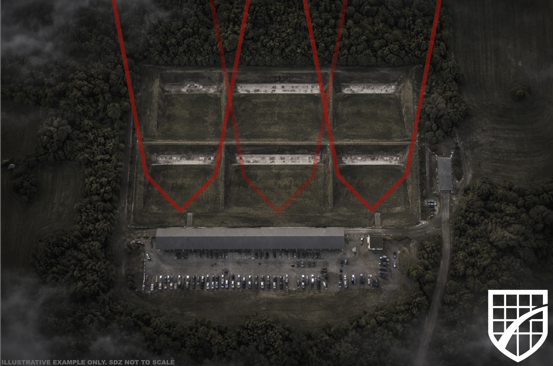
Surface Danger Zone (SDZ) Mapping & Analysis
Professional SDZ creation using military-grade methods
GIS-based accuracy for rifles, pistols, shotguns, and long-range firing
Clear documentation for boards, insurers, and attorneys
Identification of round-exit risks and required berm improvements
Range Safety Assessments
Full on-site evaluation of your range footprint
Identification of blind spots, deflection hazards, and ricochet factors
Recommendations to correct safety deficiencies
Written report you can present to your board or insurance provider
Berm & Backstop Design Recommendations
Height and angle recommendations
Soil and material considerations
Runoff, erosion, and long-term maintenance guidance
Cost-effective improvements that prevent future liability
Range Layout & Modernization Planning
Design advisement for new ranges or expansions
Shooter flow & traffic control
Target placement and lane optimization
Noise mitigation strategies for surrounding communities
Compliance & Documentation Support
Safety SOP creation or modernization
Range rules written in plain language
Club policies adapted from military standards
Preparation for inspections, audits, and insurance reviews
Ongoing Range Monitoring (Recurring Service)
Annual or quarterly SDZ updates
New development risk assessment (houses, roads, trails, etc.)
Changes in terrain captured through updated GIS data
Ensures your range stays compliant as surroundings evolve
Risk Reduction & Insurance Support
Documentation packages insurers love
Proof of compliance to reduce liability exposure
Safety reports that strengthen policy renewals
Private Landowner Safety Services
SDZ creation for private shooting land
Safe firing lane design
Recommendations to prevent rounds leaving the property
What to Expect
Add Your Heading Text Here
Why Range Operations?
Range Operations is built by professionals who work on live-fire ranges every day. Our team brings years of hands-on experience supporting and managing military training ranges, where safety decisions are made in real time and mistakes are not tolerated.
That experience includes daily exposure to active ranges, formal range operations and safety professional development, and direct responsibility for ensuring training environments remain controlled, compliant, and defensible. We don’t approach range safety from theory, we approach it from lived operational experience.
On the technical side, our SDZ modeling and mapping is handled by a certified geospatial analyst with a background in professional GIS analysis. This ensures every map, overlay, and calculation is built with the same level of precision expected in government and defense environments.
As a team, we combine operational range experience with advanced geospatial analysis to bring a level of rigor rarely seen in the private range world. The result is practical, data-backed safety planning that translates military-grade discipline into solutions civilian ranges can actually use.
There is nothing template-driven about our work. Every range is evaluated on its own terrain, layout, and use case. That’s how we replace assumptions with certainty, and why our documentation holds up under scrutiny from boards, insurers, and regulators.